🧠 Test Your Knowledge!
Changing River Environments » River Characteristics and Drainage Basins
What you'll learn this session
Study time: 30 minutes
- The key features of a drainage basin and river system
- How to identify and explain river processes like erosion, transportation and deposition
- The formation and characteristics of different river landforms
- How to interpret drainage basin hydrographs
- The factors affecting river discharge and flooding
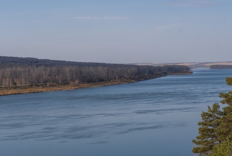
Understanding River Systems and Drainage Basins
Rivers are dynamic systems that shape our landscapes and provide essential resources for human settlements. They form part of the water cycle, carrying precipitation from higher ground to the sea in a continuous journey.
Key Definitions:
- Drainage Basin: The area of land drained by a river and its tributaries.
- Watershed: The boundary between drainage basins (also called a divide).
- Tributary: A smaller river or stream that flows into a larger river.
- Confluence: The point where two rivers meet.
- Source: The starting point of a river, often in upland areas.
- Mouth: Where a river meets the sea, a lake, or another river.
🌍 Drainage Basin as a System
A drainage basin functions as an open system with:
- Inputs: Precipitation (rain, snow, hail)
- Processes: Interception, infiltration, surface runoff, throughflow, groundwater flow
- Outputs: Evaporation, transpiration, river discharge
- Stores: Vegetation, soil, groundwater, lakes
💧 The Water Cycle in Drainage Basins
The water cycle (hydrological cycle) connects all parts of the drainage basin:
- Precipitation falls onto the drainage basin
- Water moves through various pathways (surface and subsurface)
- Water is stored temporarily in different locations
- Water eventually leaves the system via the river mouth or evapotranspiration
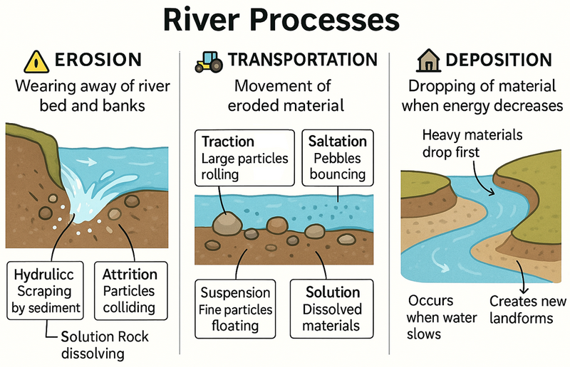
River Processes and Characteristics
Rivers change their characteristics as they flow from source to mouth. These changes are driven by three main processes:
🚧 Erosion
The wearing away of the river bed and banks:
- Hydraulic action: Force of water against banks
- Abrasion: Scraping by sediment
- Attrition: Sediment colliding and breaking down
- Solution: Dissolving of soluble rocks
🚜 Transportation
The movement of eroded material:
- Traction: Rolling of large particles
- Saltation: Bouncing of pebbles
- Suspension: Carrying of fine particles
- Solution: Dissolved materials
🏡 Deposition
The dropping of material when energy decreases:
- Occurs when velocity slows down
- Heavier materials deposited first
- Common at river bends, mouths and after floods
- Creates distinctive landforms
River Course and Profile
A river's journey from source to mouth can be divided into three main sections, each with distinctive features:
The Changing River Course
⛰ Upper Course
Characteristics:
- Steep gradient
- V-shaped valleys
- Fast-flowing, turbulent water
- Vertical erosion dominant
- Features: waterfalls, rapids, gorges
💑 Middle Course
Characteristics:
- Gentler gradient
- Wider, flatter valley floor
- Mix of erosion and deposition
- Lateral erosion becomes important
- Features: meanders, oxbow lakes
🌊 Lower Course
Characteristics:
- Very gentle gradient
- Wide, flat floodplain
- Slow-flowing water
- Deposition dominant
- Features: floodplains, levees, deltas
River Landforms
Rivers create distinctive landforms through the processes of erosion, transportation and deposition. Understanding how these landforms develop is crucial for geographical analysis.
💧 Erosional Landforms
Waterfalls and Gorges
Form when a river flows over bands of hard and soft rock. The process:
- River erodes soft rock faster than hard rock
- Creates a step in the river profile
- Water falls over the step, creating a plunge pool
- Undercutting causes the hard rock to collapse
- Waterfall retreats upstream, forming a gorge
V-Shaped Valleys
Form in the upper course through vertical erosion, creating steep valley sides that are further shaped by weathering and mass movement.
📝 Depositional Landforms
Floodplains and Levees
Floodplains form when rivers flood and deposit sediment across the valley floor. Levees are raised banks formed when the heaviest material is deposited closest to the river channel during floods.
Deltas
Form at river mouths when the river deposits its load as it enters the sea or lake. Types include:
- Arcuate (fan-shaped) - like the Nile
- Bird's foot - like the Mississippi
- Estuarine - where tides rework deposits
Meanders and Oxbow Lakes
Meanders are bends in a river that develop in the middle and lower courses. They form through a combination of erosion and deposition:
- Faster flow on the outside of a bend causes erosion (creating a river cliff)
- Slower flow on the inside leads to deposition (creating a slip-off slope)
- The meander neck narrows over time
- During a flood, the river may cut through the narrow neck
- The abandoned meander becomes an oxbow lake
Case Study Focus: River Severn, UK
The River Severn is the longest river in Great Britain (354km) and shows typical features of a river system:
- Upper Course: Begins in the Welsh mountains with steep gradients, waterfalls and V-shaped valleys
- Middle Course: Flows through Shropshire and Worcestershire with well-developed meanders
- Lower Course: Wide floodplain and estuary with extensive mudflats
- Flooding: Regular flooding affects towns like Shrewsbury and Gloucester
- Management: Various flood defences have been constructed, including embankments, flood walls and washlands
River Discharge and Hydrographs
River discharge is the volume of water flowing through a river channel measured in cumecs (cubic metres per second). It is affected by various factors and can be visualised using a hydrograph.
Understanding Hydrographs
A hydrograph is a graph showing how a river's discharge changes over time in response to rainfall. Key features include:
- Rising limb: Shows increasing discharge after rainfall
- Peak discharge: Maximum flow
- Falling limb: Shows decreasing discharge as water drains away
- Lag time: Time between peak rainfall and peak discharge
- Base flow: Normal river level from groundwater
Factors affecting the shape of a hydrograph:
- Physical factors: Drainage basin size and shape, rock type, soil type, vegetation cover, relief
- Human factors: Urbanisation, deforestation, land use changes
- Weather factors: Intensity and duration of rainfall, previous weather conditions
Quick Facts: Drainage Basin Characteristics
- The world's largest drainage basin is the Amazon Basin (7 million km²)
- Impermeable surfaces like concrete increase surface runoff and flood risk
- Vegetation intercepts rainfall, slowing its journey to the river
- Climate change is altering rainfall patterns, affecting river systems globally
- Drainage density refers to the total length of streams per unit area
Access the full course and all the resources like custom timetables and progress tracking.
Join Today