Rapids and Gorge Formation in River Systems
Rivers are powerful agents of landscape change, constantly reshaping the land through erosion, transportation and deposition. Among the most dramatic features created by rivers are rapids and gorges - spectacular landforms that demonstrate the immense erosive power of flowing water over time.
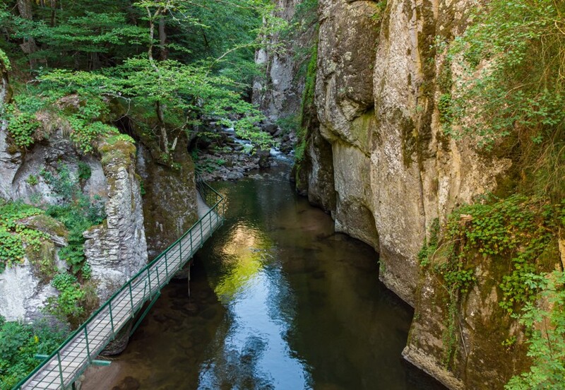
Key Definitions:
- Rapids: Sections of a river where the water flows much faster and more turbulently over a steep, rocky riverbed, creating white water.
- Gorge: A narrow, steep-sided valley usually formed by a river cutting down through resistant rock.
- Vertical erosion: The downward cutting of a river into its bed, deepening the channel.
- Resistant rock: Rock types that are harder and erode more slowly than surrounding rocks.
💦 Rapids Formation
Rapids form where a river flows over an area of harder, more resistant rock. The resistant rock erodes more slowly than softer rock upstream or downstream, creating a steeper gradient and turbulent flow. Water accelerates as it passes over these sections, creating the characteristic churning white water of rapids.
⛰ Gorge Formation
Gorges form when a river cuts vertically downward through resistant rock over long periods. This vertical erosion creates steep, sometimes near-vertical sides. Gorges are often found in the upper course of rivers where the gradient is steeper and vertical erosion dominates.
The Process of Vertical Erosion
Both rapids and gorges are primarily formed through vertical erosion, where the river cuts downward into its bed. This process is particularly dominant in the upper course of a river where the gradient is steeper and the river has more potential energy.
How Rivers Erode Vertically
Rivers use four main erosional processes to cut downward into their beds:
💧 Hydraulic Action
The force of water compresses air in cracks in the riverbed. This creates pressure that can break rock apart. This is especially powerful in rapids where water moves at high velocity.
🪨 Abrasion
Rocks and sediment carried by the river act like sandpaper, scraping and grinding away at the riverbed. This is the most effective erosional process in most rivers.
⚡ Attrition
Rocks and sediment in the river collide with each other, breaking into smaller, smoother pieces. This creates more tools for abrasion.
🧾 Solution
Chemical action where the river water dissolves soluble rocks like limestone. This is particularly important in gorge formation in limestone areas.
🚀 Potholing
Swirling stones create circular holes in the riverbed, which can eventually merge to deepen the channel, contributing to rapids and gorge formation.
🔃 Headward Erosion
The process where erosion at a waterfall or rapids causes it to gradually retreat upstream, potentially creating or extending a gorge.
Geological Factors in Rapids and Gorge Formation
The underlying geology plays a crucial role in determining where rapids and gorges form. Several geological factors can create the conditions necessary for these features:
🪨 Rock Type Variations
When a river flows across bands of different rock types, differential erosion occurs. Harder rocks (like granite or quartzite) erode more slowly than softer rocks (like shale or clay), creating steps in the river profile that form rapids. When a river cuts through a band of resistant rock surrounded by softer rock, a gorge may form.
🗟 Fault Lines
Geological faults create weaknesses in rock that rivers can exploit. Rivers may follow fault lines and where they cross particularly resistant rock sections along these faults, rapids or gorges can form as the river cuts down through the rock.
Types of Gorges
Geographers recognise several different types of gorges based on how they formed:
⛰ Antecedent Gorges
Form when a river maintains its course as land is uplifted around it. The river cuts down at the same rate as the land rises, creating a deep gorge. Example: Indus Gorge through the Himalayas.
🌊 Superimposed Gorges
Form when a river established on one type of rock cuts down into underlying different rock types, maintaining its original course despite the new geology. Example: Colorado River in the Grand Canyon.
💧 Rejuvenated Gorges
Form when a river's base level falls (due to sea level drop or land uplift), giving the river renewed erosive power to cut down rapidly. Example: Rhine Gorge in Germany.
Case Study Focus: The Grand Canyon, USA
The Grand Canyon is perhaps the world's most famous gorge, formed by the Colorado River cutting through the Colorado Plateau. At up to 1.8 km deep and 29 km wide, it showcases 2 billion years of Earth's geological history in its exposed rock layers.
Formation: The Colorado River began cutting through the plateau about 5-6 million years ago. The canyon's formation was accelerated by the uplift of the Colorado Plateau, which gave the river more potential energy for downward erosion.
Geological features: The Grand Canyon exposes rock layers ranging from 2-billion-year-old Vishnu Schist at the bottom to 270-million-year-old Kaibab Limestone at the rim. The different hardness of these rock layers creates the canyon's distinctive stepped profile.
Human significance: The Grand Canyon attracts about 6 million visitors annually and is culturally significant to several Native American tribes. It demonstrates how river erosion, combined with geological uplift, can create one of Earth's most spectacular landscapes.
Rapids and Human Interaction
Rapids have significant implications for human activities along rivers:
🚗 Transport Barriers
Rapids create natural barriers to navigation, often requiring portage (carrying boats around the obstacle) or the construction of locks and canals. Historically, rapids have determined the locations of settlements, as they marked the limit of navigable rivers and often became trading posts.
🏅 Recreational Value
Rapids provide opportunities for activities like white-water rafting, kayaking and sport fishing. This creates tourism potential for areas with spectacular rapids, bringing economic benefits to local communities. The Zambezi River below Victoria Falls has world-famous rapids that attract thousands of adventure tourists annually.
Gorges and Human Interaction
Gorges have their own set of human interactions and uses:
⚡ Hydroelectric Power
The narrow, steep-sided nature of gorges makes them ideal locations for dam construction. The Three Gorges Dam on the Yangtze River in China is built in a gorge and is the world's largest power station in terms of installed capacity (22,500 MW).
🏕 Settlement Patterns
Gorges can constrain settlement patterns, forcing linear development along the limited flat land available. They can also provide natural defences, with many historic settlements and castles built overlooking gorges for strategic advantage.
Case Study Focus: Niagara Gorge and Falls
The Niagara Gorge extends 11 km downstream from the famous Niagara Falls, cutting through layers of sedimentary rock.
Formation: The gorge formed through headward erosion as the falls gradually retreated upstream over the past 12,000 years. The falls erode backward at an average rate of 1 metre per year, though this has slowed to about 30 cm per year due to water diversion for hydroelectric power.
Human impact: Niagara Falls and its gorge attract about 30 million visitors annually. The narrow gorge creates ideal conditions for hydroelectric power generation, with plants on both the Canadian and US sides producing over 4.4 gigawatts of electricity.
Management issues: Balancing tourism, power generation and conservation presents challenges. Water is diverted for power generation during off-peak tourist hours and engineering works have been undertaken to slow erosion and prevent the falls from retreating too quickly.
Environmental Management of Rapids and Gorges
Rapids and gorges present unique management challenges:
🏠 Conservation
Many rapids and gorges are protected for their scenic, ecological and geological value. The Cheddar Gorge in Somerset is a Site of Special Scientific Interest (SSSI) and part of an Area of Outstanding Natural Beauty.
💰 Economic Development
Balancing conservation with economic opportunities from tourism and hydroelectric power requires careful planning. Sustainable tourism practices help minimise environmental impacts while supporting local economies.
🌍 Climate Change
Changing rainfall patterns due to climate change may affect river flow, potentially altering erosion rates in rapids and gorges. More extreme flood events could accelerate erosion in some areas.
Summary: The Significance of Rapids and Gorges
Rapids and gorges are dramatic examples of how rivers shape our landscape through vertical erosion. They form primarily where rivers encounter resistant rock, creating either turbulent, fast-flowing sections (rapids) or deep, narrow valleys (gorges). These features have significant impacts on human settlement patterns, transportation routes and economic activities.
Understanding the formation of rapids and gorges helps us appreciate the dynamic nature of river systems and the long timescales over which landscapes evolve. It also highlights the need for sustainable management approaches that balance human uses with conservation of these spectacular natural features.