🧠 Test Your Knowledge!
Changing River Environments » The Long Profile and River Features
What you'll learn this session
Study time: 30 minutes
- The concept of a river's long profile and its typical shape
- How gradient changes from source to mouth
- The processes of erosion, transportation and deposition
- Upper course features: V-shaped valleys, waterfalls and gorges
- Middle course features: meanders and oxbow lakes
- Lower course features: floodplains and deltas
- How these features form and their characteristics
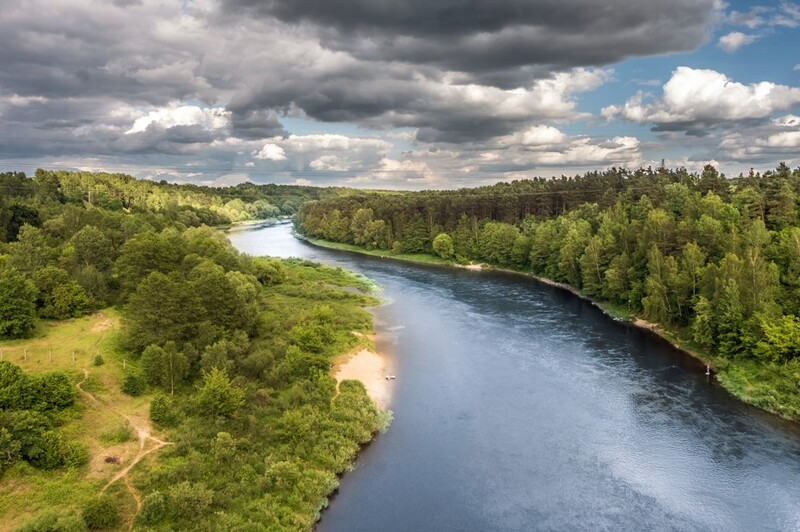
The Long Profile of a River
A river's long profile is a side-view diagram showing how a river changes from its source (where it begins) to its mouth (where it meets the sea or a lake). Understanding the long profile helps us make sense of why different river features form in different sections of a river.
Key Definitions:
- Long profile: A side-view diagram showing the changing gradient of a river from source to mouth.
- Gradient: The steepness of the river's slope.
- Source: Where a river begins, typically in highland areas.
- Mouth: Where a river ends, flowing into the sea, a lake or another river.
📍 The Typical Long Profile
Most rivers have a concave (curved) long profile. This means they start steep in the upper course, become less steep in the middle course and are nearly flat in the lower course. Think of it like a slide that's very steep at the top but gradually flattens out at the bottom.
💧 Why This Shape?
Rivers start in highlands where potential energy is high. As water flows downhill, this energy is used for erosion and transportation. By the time the river reaches lowlands, it has less energy and gradient, so deposition becomes the dominant process.
The Three Courses of a River
Geographers divide rivers into three main sections or courses, each with distinctive features formed by different processes.
⛰ Upper Course
Characteristics: Steep gradient, fast-flowing, turbulent water, vertical erosion dominant
Features: V-shaped valleys, waterfalls, rapids, gorges
🟢 Middle Course
Characteristics: Moderate gradient, smoother flow, lateral erosion becomes important
Features: Meanders, oxbow lakes, wider valleys
🌊 Lower Course
Characteristics: Gentle gradient, slow-flowing, deposition dominant
Features: Floodplains, levees, deltas, estuaries
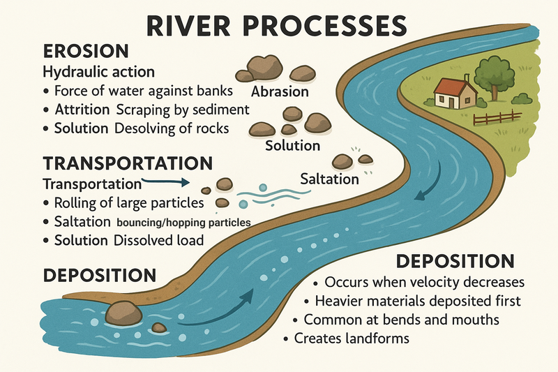
River Processes
Three main processes shape river landscapes and create the features we observe:
💣 Erosion
The wearing away of the river bed and banks through:
- Hydraulic action: Force of water hitting the banks
- Abrasion: Scraping by sediment
- Attrition: Sediment particles hitting each other
- Solution: Dissolving of soluble rocks
🚢 Transportation
Movement of eroded material by:
- Traction: Rolling along the bed
- Saltation: Bouncing along
- Suspension: Carried within the flow
- Solution: Dissolved in water
🏡 Deposition
Dropping of material when:
- River velocity decreases
- Volume of water decreases
- River enters a lake or sea
- After flooding when water recedes
Upper Course Features
V-Shaped Valleys
In the upper course, rivers have high energy and cut downwards through vertical erosion, creating steep-sided valleys. As the valley sides are exposed, weathering and mass movement cause them to retreat, forming the characteristic V-shape.
💡 Formation Process
1. River erodes downwards (vertical erosion)
2. Valley sides are exposed to weathering
3. Loose material falls into river (mass movement)
4. Material is transported away
5. Process continues, widening the valley
🔬 Identifying Features
• Steep sides
• Narrow valley floor
• River occupies most of valley floor
• Limited flat land beside river
• Often found in mountainous regions
Waterfalls and Gorges
Waterfalls form where a river flows over a band of resistant rock (hard rock) that lies on top of less resistant rock (soft rock). Over time, the waterfall retreats upstream, leaving a steep-sided gorge.
💧 Waterfall Formation
1. River flows over bands of hard and soft rock
2. Soft rock erodes faster, undercutting hard rock
3. Hard rock is left unsupported and eventually collapses
4. Fallen rocks cause more erosion through abrasion
5. Process repeats, waterfall retreats upstream
🗼 Gorge Formation
• As waterfall retreats, it leaves a steep-sided valley
• Continued vertical erosion deepens the channel
• Limited lateral erosion keeps sides steep
• Example: Malham Cove in Yorkshire was once a waterfall that has retreated, leaving a limestone gorge
Middle Course Features
Meanders
Meanders are winding bends in a river that develop as the river starts to erode laterally (sideways) as well as downwards. They form in the middle and lower courses where the gradient becomes gentler.
Case Study Focus: River Thames Meanders
The River Thames in England has many classic meanders, particularly between Oxford and Reading. These meanders have influenced settlement patterns, with towns like Henley-on-Thames developing on the outside of meander bends where the land is higher and less prone to flooding.
🔃 Meander Formation
1. Water flows faster on the outside of a slight bend
2. This causes erosion on the outside (creating a river cliff)
3. Slower flow on the inside leads to deposition (creating a slip-off slope)
4. The bend becomes more pronounced over time
5. The process continues, creating a winding pattern
📏 Key Features
• River cliff: Steep bank on outside of bend (erosion)
• Slip-off slope: Gentle slope on inside of bend (deposition)
• Thalweg: The deepest part of channel, found near the outside of bends
• Pools: Deep sections on outside of bends
• Riffles: Shallow sections between bends
Oxbow Lakes
An oxbow lake is a U-shaped body of water that forms when a meander is cut off from the main river channel. They represent the continuing evolution of meanders over time.
🏞 Formation Process
1. Meander neck becomes increasingly narrow as erosion continues
2. During a flood, the river may cut across the narrow neck
3. The new straighter route is more efficient
4. Deposition seals off the old meander
5. Isolated bend becomes an oxbow lake
6. Eventually, the lake may dry up, leaving an oxbow scar
👀 Identifying Features
• Curved, U-shaped water body
• Located close to but separated from main river
• Often becomes marshy over time as it fills with sediment
• Rich in wildlife and biodiversity
• Can be seen clearly on maps and aerial photographs
Lower Course Features
Floodplains
A floodplain is the flat area of land adjacent to a river that experiences periodic flooding. It forms through a combination of lateral erosion and deposition during floods.
🌊 Formation Process
1. River erodes laterally, widening its valley
2. During floods, water spreads across surrounding land
3. As flood recedes, sediment is deposited
4. Over time, repeated flooding builds up layers of fertile alluvium
5. The flat area expands as the river continues to meander
🌾 Importance of Floodplains
• Natural flood control - absorbs excess water
• Highly fertile soil for agriculture
• Flat land attractive for settlement and transport
• Rich ecosystems and biodiversity
• Often protected as important habitats
Deltas
A delta forms where a river meets a body of standing water (sea or lake) and deposits its sediment. The river slows down suddenly, losing energy and dropping its load of sediment, which builds up over time.
Case Study Focus: The Nile Delta
The Nile Delta in Egypt is one of the world's largest deltas, covering about 240 km of Mediterranean coastline. It's extremely fertile and supports intensive agriculture, with about half of Egypt's population living in the delta region. The construction of the Aswan Dam has reduced sediment reaching the delta, causing coastal erosion problems.
🗺 Types of Deltas
• Arcuate (fan-shaped): Nile, Ganges
• Bird's foot: Mississippi
• Cuspate (tooth-shaped): Tiber
• Estuarine: Thames, Amazon
🌐 Formation Factors
• River must carry large sediment load
• Sea or lake must be relatively calm
• Tidal and wave action must be limited
• Rate of deposition must exceed rate of removal
• Shape depends on balance between river, wave and tidal processes
Human Interactions with River Features
River features create both opportunities and challenges for human activities:
🏠 Settlement
• Floodplains provide flat land for building
• Meanders create defensive sites
• Deltas offer fertile farming land
• Waterfalls can provide energy
⚠ Hazards
• Flooding on floodplains
• Lateral erosion threatening property
• Changing river courses affecting boundaries
• Subsidence in delta regions
📦 Management
• Flood defences on floodplains
• Bank reinforcement at meanders
• Dams affecting sediment supply to deltas
• Tourism at waterfalls and gorges
Summary
Rivers are dynamic systems that change from source to mouth, creating distinctive landforms through the processes of erosion, transportation and deposition. The long profile helps us understand why certain features form in different sections of a river:
- Upper course: Steep gradient, vertical erosion dominant, creating V-shaped valleys, waterfalls and gorges
- Middle course: Moderate gradient, lateral erosion becomes important, forming meanders and oxbow lakes
- Lower course: Gentle gradient, deposition dominant, creating floodplains and deltas
Understanding these features and processes helps us appreciate how rivers shape our landscape and influence human activities.
Access the full course and all the resources like custom timetables and progress tracking.
Join Today