Introduction to V-shaped Valley Development
V-shaped valleys are one of the most distinctive landforms created by rivers, especially in their upper course. These dramatic landscape features tell the story of how water shapes our planet over thousands of years. In this session, we'll explore how these valleys form, develop and change over time.
Key Definitions:
- V-shaped valley: A steep-sided valley with a narrow bottom that resembles the letter 'V' when viewed in cross-section, formed primarily by river erosion.
- Vertical erosion: The downward cutting of a river into its bed, deepening the channel.
- Lateral erosion: The sideways cutting of a river into its banks, widening the channel.
- Interlocking spurs: Projections of higher land that extend into a valley from opposite sides, appearing to interlock when viewed from above.
💧 River Stages and Valley Formation
Rivers have three main courses - upper, middle and lower. V-shaped valleys are typically found in the upper course where the river has high energy and flows through steep terrain. In this stage, vertical erosion dominates over lateral erosion, creating the distinctive V shape as the river cuts downward.
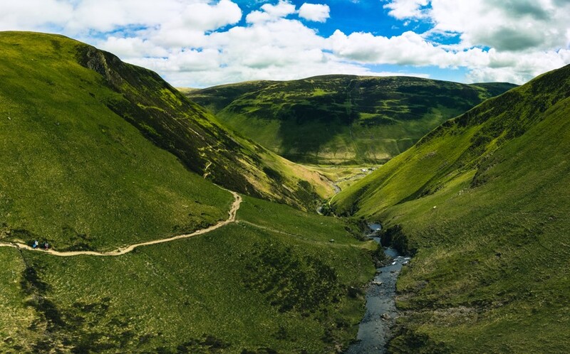
⛰ Valley Cross-Section
The classic V-shaped valley has steep sides that meet at a narrow valley floor. The steepness of the sides depends on factors like rock type, climate and the river's erosive power. Harder rock types create steeper valley sides, while softer rocks result in more gentle slopes.
How V-shaped Valleys Form
V-shaped valleys don't form overnight - they're the result of thousands of years of persistent erosion by rivers. Let's explore the key processes that create these dramatic landscape features.
Erosion Processes
Rivers erode the landscape through four main processes that work together to create V-shaped valleys:
💥 Hydraulic Action
The force of water hitting the river bed and banks, forcing air into cracks which creates pressure and weakens the rock.
🪨 Abrasion
The river's load (pebbles, stones and boulders) scrapes against the bed and banks like sandpaper, wearing away the surface.
💦 Corrosion
The chemical reaction between water and rock that dissolves certain minerals, particularly in limestone areas.
🎉 Attrition
The process where rocks and pebbles in the river collide with each other, becoming smaller and more rounded over time.
The Development Stages of V-shaped Valleys
V-shaped valleys develop through a series of stages as the river continues to erode the landscape. Understanding this progression helps us see how landscapes evolve over time.
📊 Initial Downward Cutting
In the upper course, the river has high potential energy due to the steep gradient. This energy is used primarily for vertical erosion, cutting downward into the river bed. The river follows the path of least resistance, creating a winding course through the landscape.
🌍 Valley Deepening
As vertical erosion continues, the valley becomes deeper. The steep sides are further shaped by weathering and mass movement (like soil creep and landslides), which cause material to move downslope into the river. This material is then carried away by the river, maintaining the V shape.
Interlocking Spurs
A key feature of young V-shaped valleys is the presence of interlocking spurs. These are ridges of higher land that project into the valley from alternate sides. The river winds around these obstacles, creating a meandering path through the mountains.
Interlocking spurs form because:
- The river follows the path of least resistance through varying rock hardness
- The river lacks the energy to cut straight through all obstacles
- The winding course becomes more pronounced as erosion continues
Case Study Focus: The River Tees, UK
The River Tees in northern England provides an excellent example of V-shaped valley development. In its upper course near High Force waterfall, the Tees has carved a classic V-shaped valley through the hard rocks of the Pennine uplands. The valley is particularly steep-sided where it cuts through the resistant Whin Sill (a layer of dolerite rock). High Force itself demonstrates the power of vertical erosion, with the river dropping 21 metres over the waterfall, continuing to deepen its valley.
Further upstream, the Tees winds between interlocking spurs, creating a meandering path through the upland landscape. This section of the river clearly shows how the early stages of V-shaped valley development progress, with the river following the path of least resistance through the varied terrain.
Factors Affecting V-shaped Valley Development
Several factors influence how V-shaped valleys develop and their final appearance:
🪨 Rock Type and Structure
The type of rock has a major impact on valley development. Hard, resistant rocks like granite create steeper valley sides, while softer rocks like shale or limestone erode more quickly and create gentler slopes. Joints and bedding planes in the rock can also create weaknesses that the river exploits.
🌞 Climate
Climate affects valley development through rainfall patterns and temperature. Higher rainfall increases river discharge and erosive power. In cold regions, freeze-thaw weathering can break up rocks on valley sides, while in warm, wet climates, chemical weathering may dominate.
The Balance of Forces
V-shaped valleys represent a balance between different forces:
- Vertical erosion - The river cutting downward
- Weathering processes - Breaking down rocks on the valley sides
- Mass movement - Material moving downslope into the river
- Transportation - The river carrying away eroded material
When vertical erosion dominates, the valley becomes deeper. If weathering and mass movement happen quickly, the valley sides become less steep. The classic V shape occurs when these processes work in relative balance.
Case Study Focus: Glaciated V-shaped Valleys
Some V-shaped valleys have been modified by glaciation during ice ages. When glaciers occupy a pre-existing V-shaped valley, they transform it into a U-shaped valley with steeper sides and a flatter bottom. The Lauterbrunnen Valley in Switzerland is a famous example where you can see this transition. Originally carved as a V-shaped valley by the White Lütschine river, it was later modified by glaciers during the ice ages, creating an unusually steep-sided U-shaped valley that's often described as a "textbook example" of glacial erosion.
Human Impacts on V-shaped Valleys
Humans have significantly altered many V-shaped valleys through various activities:
🛡 Dam Construction
V-shaped valleys are often ideal locations for dams because their narrow profile requires less construction material. However, dam construction floods valleys, completely changing their character and ecology.
🏘 Settlement
People have settled in valleys for thousands of years, building villages and towns that modify the natural landscape through terracing, flood defences and infrastructure development.
🚜 Transport Routes
Roads and railways often follow river valleys, requiring cutting into valley sides and building bridges that alter the natural processes of erosion and deposition.
Management and Conservation
Many V-shaped valleys are now protected as areas of natural beauty or scientific interest. Management approaches include:
- Restricting development to preserve natural landscapes
- Managing forests on valley sides to prevent excessive erosion
- Creating national parks and protected areas
- Sustainable tourism that allows people to appreciate these landscapes without damaging them
Did You Know?
The steepest V-shaped valleys in the world can be found in the Himalayas, where powerful rivers like the Indus and Brahmaputra have cut deep gorges through the rapidly rising mountain range. The Kali Gandaki Gorge in Nepal is considered by some to be the deepest valley in the world, with a depth of 5,571 metres from river to mountain peaks!
Summary: The Importance of V-shaped Valleys
V-shaped valleys are more than just interesting landforms - they're vital parts of our planet's water systems and provide important habitats for wildlife. They represent the power of water to shape landscapes over time and tell the story of Earth's geological history.
Understanding how these valleys form and develop helps us appreciate the dynamic nature of our planet and the ongoing processes that continue to shape the land around us. Next time you see a steep-sided valley with a river running through it, you'll know the fascinating story behind its formation!