Introduction to Levee and Floodplain Formation
Rivers are dynamic systems that constantly shape our landscape through erosion, transportation and deposition. Two key landforms created by these processes are levees and floodplains, which form in the middle and lower courses of rivers. These features are crucial for understanding river behaviour, flood management and human settlement patterns.
Key Definitions:
- Levee: A raised ridge of sediment that forms along the banks of a river, created by repeated flooding and deposition.
- Floodplain: The flat area of land adjacent to a river that experiences periodic flooding and is formed by the deposition of sediment during flood events.
- Deposition: The process by which a river drops or deposits material (sediment) that it has been carrying.
- Discharge: The volume of water flowing through a river channel at a given point, measured in cubic metres per second (cumecs).
🌊 The River System
Rivers change as they flow from source to mouth. In the upper course, rivers are typically fast-flowing with narrow channels. As they reach the middle and lower courses, they slow down, have more discharge and develop wider channels with distinctive features like levees and floodplains. These changes happen because of decreasing gradient, increasing discharge and changing sediment loads.
🚗 Transport and Deposition
Rivers transport materials in three ways: solution (dissolved materials), suspension (fine particles carried within the water) and bed load (larger particles rolled or bounced along the riverbed). When a river's energy decreases, it can no longer transport all its load, leading to deposition. This process is crucial for levee and floodplain formation.
Levee Formation
Levees are natural embankments that form alongside river channels. They develop through a series of flooding events and are most prominent in the middle and lower courses of rivers. Here's how they form:
The Process of Levee Formation
💧 Step 1: Flooding
When a river floods, water spills over the banks and onto the surrounding land. The river's velocity suddenly decreases as it leaves the confined channel.
🌑 Step 2: Deposition
As the water slows down, it loses energy and can no longer transport all its sediment. The largest and heaviest particles are deposited first, right at the edge of the channel.
📝 Step 3: Build-up
With each flood, more sediment is deposited on top of previous deposits. Over time, this builds up to form raised banks or ridges along the sides of the river - these are levees.
The coarsest material (sand and small pebbles) is deposited closest to the river channel, while finer silts and clays are carried further onto the floodplain. This sorting of material creates a distinctive profile where levees slope gently away from the river. As levees grow higher, they can actually contain small floods within the channel, with only larger floods spilling over.
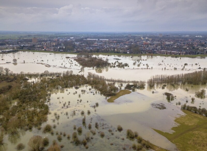
Floodplain Formation
Floodplains are the flat areas of land adjacent to rivers that are subject to periodic flooding. They form in the middle and lower courses of rivers where the gradient is gentler and the channel is less confined.
How Floodplains Develop
Floodplains develop through a combination of lateral erosion and deposition:
🔃 Lateral Erosion
As rivers flow, they erode their banks laterally (sideways), especially on the outside of meanders where flow is fastest. This lateral erosion gradually widens the valley floor, creating space for the floodplain to develop. Over time, the river may carve out a wide, flat valley.
🌞 Flood Deposition
When rivers flood, they deposit layers of sediment across the valley floor. Fine silts and clays are carried furthest from the channel and settle on the floodplain. Each flood adds a new layer of alluvium (river-deposited material), gradually building up the floodplain surface.
Floodplains often contain distinctive features formed by river processes:
- Meander scars: Curved depressions left when a meander is cut off and abandoned
- Oxbow lakes: Curved lakes formed when a meander is cut off from the main river
- Backswamps: Low-lying, marshy areas in the floodplain furthest from the river
- Braided channels: Multiple smaller channels that split and rejoin across the floodplain
Case Study Focus: The Mississippi River
The Mississippi River in the USA has one of the world's most extensive floodplain and levee systems. Its floodplain covers over 90,000 square kilometres across several states. Natural levees along the Mississippi can reach heights of 4-5 metres, though many have been artificially reinforced.
In 1927, catastrophic flooding occurred when levees failed in 145 places, flooding an area of 70,000 square kilometres and displacing 700,000 people. This disaster led to the comprehensive Mississippi River and Tributaries Project, which included strengthening levees, creating floodways and building control structures.
Today, the Mississippi's levee system stretches for over 3,500 kilometres, protecting communities and farmland. However, some scientists argue that constraining the river with levees prevents natural floodplain processes and may increase flood risks downstream.
The Importance of Levees and Floodplains
🌿 Ecological Importance
Floodplains are among the most biologically productive ecosystems on Earth. Regular flooding brings nutrients that support diverse plant and animal communities. Wetlands in floodplains filter water, recharge groundwater and provide habitat for fish, birds and other wildlife. Levees create distinct ecological zones with different soil conditions and vegetation types.
🏠 Human Significance
Throughout history, humans have settled near rivers, using floodplains for agriculture due to their flat terrain and fertile soils. Natural levees often provided slightly elevated, well-drained sites for settlements. Today, many major cities are located on floodplains, protected by both natural and artificial levee systems. However, development on floodplains increases flood risk and can disrupt natural river processes.
Human Modification of Levees and Floodplains
People have extensively modified natural levees and floodplains to control flooding and utilise these landscapes:
- Artificial levees: Natural levees are often reinforced or artificial ones constructed to provide greater flood protection. These are typically higher and steeper than natural levees.
- Channelisation: Rivers are straightened and deepened to increase flow capacity and reduce flooding.
- Flood relief channels: Artificial channels constructed to divert excess water during floods.
- Controlled flooding: Some areas implement managed flooding of parts of the floodplain to protect more valuable areas.
- Land use zoning: Restricting development in high-risk flood areas.
Case Study Focus: The River Thames, UK
The River Thames floodplain has been extensively modified over centuries. In London, the Thames Barrier (completed in 1982) works alongside embankments, floodwalls and pumping stations to protect the city from tidal flooding. The barrier has been raised over 190 times since its construction.
Upstream of London, more natural approaches are being implemented. The Jubilee River, a 11.6 km artificial channel completed in 2002, diverts floodwater away from populated areas like Windsor and Maidenhead. Projects like the Maidenhead, Windsor and Eton Flood Alleviation Scheme combine engineered solutions with floodplain restoration.
The Thames catchment demonstrates how both hard engineering (barriers, embankments) and soft engineering (floodplain restoration, washlands) can work together in flood management.
Challenges and Future Considerations
Climate change is altering rainfall patterns and increasing the frequency of extreme weather events, putting greater pressure on levee and floodplain systems. Rising sea levels also affect coastal floodplains and river deltas. In response, many regions are moving towards more sustainable approaches:
- Making room for rivers: Allowing controlled flooding in designated areas rather than trying to contain all floods
- Floodplain restoration: Returning developed floodplains to their natural state to absorb flood waters
- Sustainable drainage systems: Reducing runoff from urban areas to decrease flood peaks
- Integrated catchment management: Looking at the entire river basin rather than just local flood defences
Understanding levee and floodplain formation is essential for sustainable river management, flood protection and preserving these valuable ecosystems. As our climate changes, this knowledge becomes increasingly important for communities living alongside rivers worldwide.