💧 The River System
A river system has three main courses:
- Upper course: Near the source, steep gradient, narrow and shallow
- Middle course: Moderate gradient, wider and deeper
- Lower course: Near the mouth, gentle gradient, widest and deepest
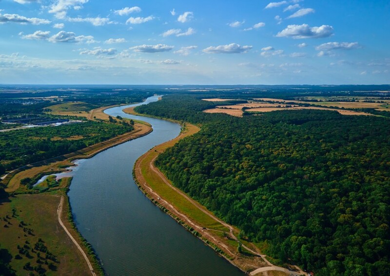
Rivers are dynamic systems that change dramatically from their source (where they begin) to their mouth (where they enter the sea or a lake). Four key characteristics that change along a river's course are width, depth, velocity (speed of flow) and discharge. These changes help explain why rivers look and behave differently as they flow downstream.
Key Definitions:
A river system has three main courses:
The Bradshaw Model shows how river characteristics change from source to mouth. It predicts that width, depth, velocity and discharge all increase downstream as the river collects more water from tributaries and rainfall.
River width typically increases from source to mouth. At the source, rivers are often just a few metres wide, but by the time they reach their mouth, they can be hundreds or even thousands of metres across.

Several processes contribute to river widening:
Lateral (sideways) erosion becomes more dominant in the middle and lower courses. The river erodes its banks through processes like hydraulic action and corrasion, making the channel wider.
As tributaries join the main river, they add more water, requiring a wider channel to accommodate the increased volume.
In the middle and lower courses, rivers develop meanders (bends). The outer bend erodes while the inner bend receives deposits, gradually widening the overall river valley.
River depth generally increases from source to mouth. In the upper course, rivers might be just centimetres deep, while in the lower course they can be several metres deep.
River depth is influenced by:
In the upper course, vertical erosion dominates as the river cuts downward into the riverbed. This creates V-shaped valleys but doesn't significantly deepen the water itself.
As rivers flow downstream, the channel becomes more efficient. Smoother beds and banks reduce friction, allowing water to pile up rather than spread out, increasing depth.
Geographers measure river depth using a measuring rod in shallow sections or echo sounding in deeper parts. They typically take measurements at several points across the channel to create a cross-section profile. The average depth can be calculated by dividing the cross-sectional area by the width.
Velocity generally increases from source to mouth, though it can vary significantly based on local conditions. Typical velocities range from 0.1-0.5 m/s in the upper course to 3-5 m/s in the lower course during normal flow.
Steeper slopes in the upper course should create faster flow, but this is often counteracted by greater friction from the rough channel.
Rough, rocky beds in the upper course create friction that slows water down. Smoother channels downstream reduce friction, increasing velocity.
Deeper, more efficient channels in the lower course have less water in contact with the bed and banks, reducing friction and increasing velocity.
The River Severn in the UK shows clear velocity changes. Near its source in the Welsh mountains, average velocity is around 0.5 m/s. By Shrewsbury in the middle course, it increases to about 1.2 m/s. Near Gloucester in the lower course, normal velocity reaches 2.5 m/s. During floods, velocities can double or triple these values, causing significant erosion and flooding risks.
Discharge is perhaps the most dramatic change along a river's course. It typically increases from just a few litres per second at the source to thousands of cubic metres per second at the mouth.
Discharge is calculated using the formula:
Discharge (m³/s) = Width (m) × Depth (m) × Velocity (m/s)
This explains why discharge increases downstream - all three components generally increase:
Each tributary that joins the main river adds its discharge to the total. The Amazon River, for example, has over 1,100 tributaries, which is why it has the world's largest discharge at around 209,000 cubic metres per second - enough to fill 84 Olympic swimming pools every second!
Discharge varies seasonally and after rainfall events. During heavy rain, discharge increases rapidly, sometimes leading to flooding. This is why geographers study river hydrographs, which show how discharge changes over time after rainfall.
Width, depth, velocity and discharge don't change in isolation - they're all connected. Understanding these connections helps explain why rivers behave as they do.
An important concept that links these variables is the hydraulic radius - a measure of channel efficiency. It's calculated as:
Hydraulic Radius = Cross-sectional Area ÷ Wetted Perimeter
As rivers flow downstream:
The River Thames demonstrates these changes clearly. Near its source in the Cotswolds, it's just 2-3 metres wide and 30cm deep, with a discharge of about 1 cubic metre per second. By the time it reaches London, it's approximately 250 metres wide and 9 metres deep, with an average discharge of 65 cubic metres per second. During floods, this can increase to over 500 cubic metres per second. These changes reflect all the processes we've discussed - tributary inputs, changing channel efficiency and the balance between erosion and deposition.
For your GCSE fieldwork, you might measure these variables in a local river. Here's how:
Use a tape measure stretched across the river from bank to bank. Take measurements at several sites moving downstream.
Use a meter stick at regular intervals across the channel to create a cross-section. Calculate average depth from multiple readings.
Time how long it takes a float to travel a set distance. Repeat several times and calculate the average. Remember that surface velocity is faster than average velocity (multiply by 0.85 for a correction).
With these measurements, you can calculate discharge and see for yourself how these variables change along a river's course!
Access the full course and all the resources like custom timetables and progress tracking.
Join Today