Understanding River Environments
Rivers are dynamic systems that shape our landscapes and provide vital resources. As they flow from source to mouth, they create diverse environments that are constantly changing. Let's explore the key components that make up river systems.
Key Definitions:
- Wetted Perimeter: The length of the cross-sectional line that is "wet" or in contact with water in a river channel.
- Channel: The physical confine of a river or stream consisting of a bed and banks.
- Watershed (Drainage Basin): The area of land where all precipitation drains to a common outlet such as a river, lake, or ocean.
💧 Wetted Perimeter
The wetted perimeter is a crucial measurement in river studies. It tells us how much of the river channel is in contact with water at any given time. This affects:
- Water velocity and discharge
- Friction between water and the channel
- Erosion and deposition patterns
- Habitat availability for aquatic organisms
A larger wetted perimeter means more friction, which can slow water flow. This is why shallow, wide rivers often flow more slowly than deep, narrow ones with the same volume of water.
📍 Measuring Wetted Perimeter
Geographers measure wetted perimeter by:
- Taking cross-sectional measurements of the river channel
- Measuring the length of the line where water meets the channel bed and banks
- Using this data to calculate hydraulic radius (cross-sectional area ÷ wetted perimeter)
The hydraulic radius helps predict how efficiently a river can transport water and sediment, which is essential for understanding flood risks and river management.
River Channels: Form and Function
River channels are the pathways that water follows as it moves downstream. Their shape and characteristics change from source to mouth, affecting how the river behaves.
Channel Characteristics
River channels have several key features that geographers study:
📏 Width and Depth
As rivers flow downstream, they typically become:
- Wider - due to increased discharge and erosion
- Deeper - as more tributaries join
- More efficient at carrying water (higher width-depth ratio)
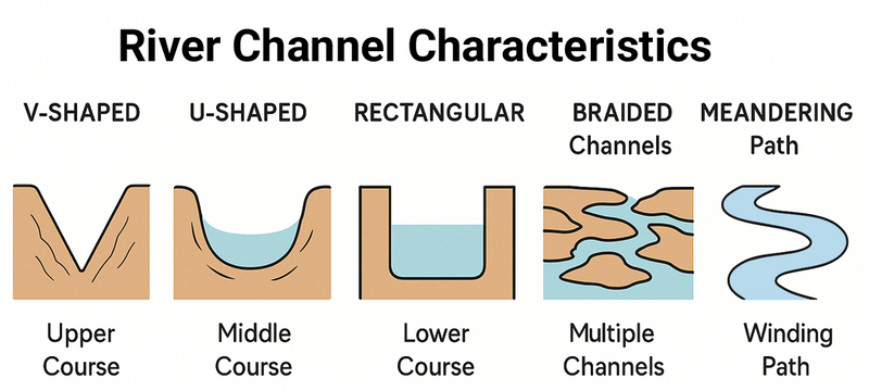
🛠 Channel Shape
Channels can be:
- V-shaped - common in upper courses
- U-shaped - found in middle courses
- Rectangular - typical in lower courses
- Braided - multiple channels separated by small islands
- Meandering - winding paths with distinct bends
🌊 Channel Efficiency
Efficiency depends on:
- Hydraulic radius - higher values mean greater efficiency
- Roughness - smoother channels are more efficient
- Gradient - steeper slopes increase velocity
- Wetted perimeter - affects friction and flow speed
Understanding Watersheds
A watershed (or drainage basin) is the entire land area that drains into a particular river system. It's bounded by higher ground called watersheds or drainage divides.
🌍 Watershed Features
Key elements of a watershed include:
- Drainage divide: The boundary separating one watershed from another
- Tributaries: Smaller streams that feed into the main river
- Confluence: Where two streams or rivers join
- Source: Where the river begins (often in highlands)
- Mouth: Where the river meets a larger body of water
- Floodplain: Flat land adjacent to the river that floods during high water
💦 Watershed Processes
Important processes within watersheds:
- Interception: Rainfall caught by vegetation before reaching the ground
- Infiltration: Water soaking into the soil
- Surface runoff: Water flowing over the land surface
- Throughflow: Water moving horizontally through soil
- Groundwater flow: Water moving through rocks beneath the surface
- Evapotranspiration: Water returning to the atmosphere from soil and plants
The Relationship Between Wetted Perimeter, Channel and Watershed
These three elements are interconnected in river systems:
- The watershed determines how much water enters the river system
- The channel shape and wetted perimeter affect how efficiently that water is transported
- Changes to any one element can impact the others and the overall river environment
For example, deforestation in a watershed can lead to increased runoff, which may cause channel widening and a larger wetted perimeter. This in turn can alter erosion patterns and flood risks downstream.
Case Study Focus: The River Thames, UK
The River Thames provides an excellent example of how wetted perimeter, channel characteristics and watershed management interact:
- The Thames watershed covers about 13,000 square kilometres of southern England
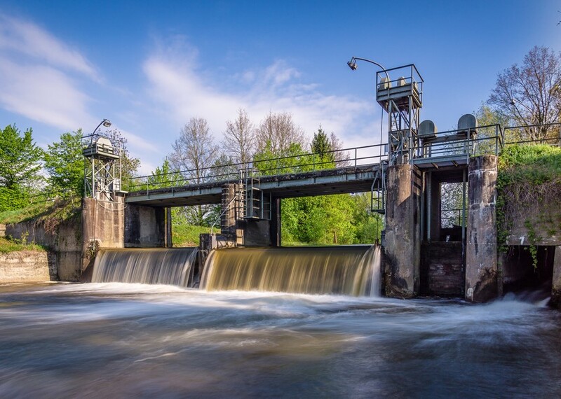
- Channel modifications (straightening, deepening) have been made throughout history to improve navigation and reduce flooding
- The Thames Barrier was constructed to protect London from tidal surges, effectively managing the channel's capacity
- Wetted perimeter measurements help engineers monitor river health and predict flood risks
- Watershed management includes controlling urban development, preserving wetlands and managing agricultural runoff
Recent restoration projects have focused on returning parts of the Thames to a more natural state, recognising that working with natural processes often provides more sustainable river management.
Human Impacts on River Environments
Human activities can significantly alter river environments:
🏠 Development Impacts
Urban development and agriculture can affect rivers by:
- Increasing impermeable surfaces, leading to faster runoff
- Channelisation - straightening and deepening rivers
- Building dams and reservoirs that alter flow patterns
- Extracting water for irrigation and domestic use
- Introducing pollutants from industry and farming
🌿 Sustainable Management
Sustainable approaches to river management include:
- River restoration - returning channels to more natural forms
- Watershed protection - preserving forests and wetlands
- Sustainable drainage systems (SuDS) in urban areas
- Natural flood management - using floodplains and wetlands
- Water quality monitoring and pollution control
Fieldwork Techniques
Studying river environments often involves fieldwork. Here are some common techniques used to measure wetted perimeter, channel characteristics and watershed features:
- Wetted perimeter measurement: Using a measuring tape across the channel where water meets the bed and banks
- Channel cross-section: Taking depth measurements at regular intervals across the channel
- Flow velocity: Using a flow meter or timing a floating object over a set distance
- Discharge calculation: Multiplying cross-sectional area by velocity
- Watershed mapping: Using topographic maps or GIS to identify drainage divides
- Land use surveys: Recording how the watershed is being used (forest, agriculture, urban, etc.)
Exam Tip!
For your iGCSE Geography exam, remember to:
- Use specific terminology correctly (wetted perimeter, hydraulic radius, watershed, etc.)
- Explain the relationships between different river components
- Include case study examples of river management and environmental change
- Discuss both physical processes and human impacts on river environments
- Consider sustainable management approaches and their effectiveness
Summary
River environments are complex systems where the wetted perimeter, channel characteristics and watershed features all interact. Understanding these elements helps geographers predict how rivers will behave, especially during extreme events like floods. Human activities can significantly alter these natural systems, making sustainable management essential for protecting both people and environments.
In your next study session, we'll explore how these concepts apply to specific river landforms and processes of erosion, transportation and deposition.